 |
2.
GENERAL DESCRIPTION OF THE MINES AND THEIR GEOLOGY
2.2 The Maastrichtian chalk of South-Limburg |
Internet preparation:Ed
Stevenhagen (Stevenhagen Geo Informatica) with permission of the
author
https://www.sintpietersberg.com
|
2.
GENERAL DESCRIPTION OF THE MINES AND THEIR GEOLOGY
2.2 The Maastrichtian chalk of South-Limburg |
| 2.1 GEOLOGICAL SETTING |
| The area of South Limburg
is situated to the north of the Hereynlan Ardennes-Rhenish Massif and at
the eastern margin of the Caledonian Brabant Massif (Fig. 2. 1)
The direct vicinity of these two massifs greatly influenced sedimentation.
From the Upper Carboniferous onwards sedimentation was also significantly
affected by the NW-SE trending faults of the Roer Valley Graben. Fig. 2.2
shows a simplified geological map of South Limburg.
In the area no sediments from the Upper Carboniferous (Stephanian) until the beginning of the Upper Cretaceous can be found (Kuyl, 1980). During the worldwide transgression period of the Upper Cretaceous the Brabant Massif was flooded (Ziegler, 1982). Also the Ardennes-Rhenish Massif was reached by this transgression. In the area studied, Upper Cretaceous sedimentation started with the deposition of lagoonal clays and sands, the Formation of Aachen, unconformably on top of the folded Carboniferous. Subsequently the shallow marine glauconitic sands of the Formation of Vaals and the fine-grained mudstones of the Formation of Gulpen were deposited in a clearly marine environment (Kuyl, 1980). It was already recognized in the 19th century by Binkhorst van den Binkhorst that the Upper Cretaceous sediment succession is a transgressive-regressive sequence (Zijlstra, 1994). This regression is characterized by the shallow marine carbonate sands of the Formation of Maastricht and by the marly Formation of Kunrade. The regression is considered by various authors to be brought about by epi-orogenetic movements (Zijlstra, 1994). During the Tertiary the Upper Cretaceous sediments were uplifted above sea-level and the limestones became affected by dissolution and karstification. At the beginning of the Tertiary Southern Limburg became situated at the margin of the Cenozoic North Sea Basin. Only between Valkenburg and Maastricht, Lower Paleocene sediments, the Limestone of Houthem, can be found. No Eocene sediments have been found in the area. A period of transgression resulted in the deposition of Lower Oligocene sands (Formation of Tongeren) and Middle Oligocene sands and clays (Formation of Rupel). Then a new period of non-deposition occurred. The sands and browncoal layers of Middle Miocene age (Breda Formation) are the last sediments in South Limburg deposited in a coastal marine environment. The period from Upper Miocene to present time is characterised by the deposition of alluvial sediments of the river Maas and its tributaries. Commonly Upper Pleistocene loess deposits are to be found at the topographic surface. Reviews of the regional geology are to be found in Kuyl (1980), Bless (1983) and Felder (1989). An overview of the interaction of sedimentation and tectonics in Limburg and its vicinity is given by Geluk et al. (1994). |
| 2.2 THE MAASTRICHTIAN CHALK OF SOUTH LIMBURG |
| During the Upper Cretaceous
widespread deposition of chalk occurred in Northwest Europe (Fig. 2. 1).
The chalk generally contains numerous flint layers. In most parts true
chalk s.s. can be found, which is a light-coloured, friable calcilutite
(Table 2.1) mainly composed of coccoliths 1)
and their fragments. This very fine-grained limestone is well known, for
example, from the white cliffs of Dover and is used for writing on the
blackboard. Locally a much coarser-grained, tuffaceous chalk (French: tuffeau,
Dutch: tufkrijt) has been preserved, which is actually not a true chalk
as defined above. Tuffaceous 2)
chalk is a designation for weak, porous limestones which can be characterized
according to grain-size as calcarenites and calcisiltites (see Table 2.
1). This chalk is of Maastrichtian age and occurs in South Limburg and
in the adjacent area of Belgium towards the west as well as in SW France.
An extensive study of the sedimentology of the (tuffaceous) chalk of South Limburg, particularly of authigenesis 3) of flints and hardgrounds, is presented by Zijlstra (1994). 1. Minuscule calcite plates
originating from unicellular planktonic algae
|
2.2.1 Lithostratigraphic subdivision
| Fig. 2.3 shows the lithostratigraphic subdivision of the Upper Cretaceous chalk of South Limburg (Felder, 1975). This subdivision has been established on the basis of laterally continuous flint layers and erosion surfaces. Two Upper Cretaceous limestone formations are distinguished: the Formation of Gulpen and the younger Formation of Maastricht. Apart from the lowermost part of the Formation of Gulpen, the Upper Campanian Limestone of Zeven Wegen, both formations are considered to be of Maastrichtian age. The coarsening upwards sequence formed by the Maastrichtian carbonate rocks starts with coccolithic, partly clayey calcilutites, such as the Limestone of Vijlen. Here the true "blackboard" chalk is represented. The overlying Lixhe 1,2,3 and Lanaye Limestones of the Formation of Gulpen are mainly coccolithic calcisiltites with numerous flint layers. |
2.2.2 The Formation of Maastricht
| The commonly coarser grained
limestones of the Formation of Maastricht were deposited in a shallow sea
and their lateral uniformity is limited. Two different facies developments
can be recognized. In the western part of Southern Limburg it is developed
as the "Maastricht facies", in the eastern
part as the "Kunrade facies". The distribution
of the Formation of Maastricht in South Limburg and the facies boundary
are displayed in Fig. 2.4. The maximum overall thickness of the formation
is about 100 m. As a result of the uplift of the Ardennes-Rhenish Massif
and the subsidence of the Rhine-Ruhr Valley graben the Formation of Maastricht
dips about 1 '30' towards the northwest (Felder, 1989).
In the eastern part of Southern Limburg the upper part of the formation is not present. The lower part consists of alternating hard, relatively well cemented limestones and soft limestones with some clay content, representing the "Kunrade" facies of the Maastrichtian Limestone. |
2.2.3 The "Maastricht facies" limestone
| The building stone mines
were almost exclusively excavated in the "Maastricht facies" limestone
(Felder, 1973). All members of this facies comprise predominantly carbonate
bioclasts of sand-size. This sequence of calcarenites is also known as
the tuffaceous chalk of Maastricht 4). The low concentration of terrigenous
siliciclasties is probably due to a low relief of the continent of Northwest
Europe. The chalk was deposited at rates of centimeters to decimeters per
1000 years (Zijlstra, 1994). The limestones are characterized by fining
upwards cycles with a coarse-grained basis of bioclastic sand that may
contain even gravel-sized fossil fragments, while the finergrained top
consists of silt-sized bioclasts which are generally homogeneously bioturbated.
The bioturbated zone is lithified in various degrees, producing
In the lower three units lithification is often poorly developed and layers of flint noduleS6 occur instead. In the upper part of the formation flints are largely absent. With the exception of the lowermost unit, the CaCO3 content is high and rarely less than 96 % (Felder, 1973). Apart from the hardgrounds the calcarenites are soft, weakly cemented and highly porous. Porosities of 40 to 52 % have been measured (Price & Verhoef, 1988). Additionally, the grains are loosely bonded and evidence of pressure-solution or compaction is hardly observed. As a consequence strength is low, i.e. the unconfined compressive strength amounts only to a few MPa. Apart from hardgrounds, layers of fossil grit and flint layers sedimentary bedding is generally not visible, even under the optical microscope. However, geomechanical tests show a transverse isotropy', as shown in Chapter 5. 4. It should be noted that
in both popular and scientific literature the Dutch word "merger" (English:
marl, French: mame, German: mergel) is often used for the nearly pure limestones
of the "Maastricht" facies limestones, probably because of their comparable
softness. Since marl is defined as a mixture of clay and fine-grained carbonate
material, this designation is not correct.
|
2.2.4 Microstructure
| Fig. 2.5 shows a typical
microstructure of the "Maastricht facies" Formation of Maastricht. The
sample is taken from the upper part of the Emael Limestone in the Sibbergroeve.
A well sorted elastic carbonate rock is to be seen, displaying a grain
size ranging from 0. 1 to 0.4 mm (calcarenite). On the basis of the grain
supported texture and the absence of mud it can be classified as a grainstone
according to the Dunham (1962) classification system.
The allochems mainly consist of fragments of mesofossils (fossils varying in size from 1 to 2.4 mm). They underwent strong micritization, in most cases resulting in the elimination of observable internal structure. Fresh micrite between the grains is absent. Therefore the micritization could have occurred before transportation of the grains. Many particles display very fine (less than 0.02 mm long) "dogtooth" cement overgrowth. Some particles probably representing nuclei of echinoderms show syntaxial overgrowth, but as a whole cementation is very poorly developed. As a consequence the porosity is high and the strength is low. 7 Transverse isotropy of a sedimentary bedded rock means that its mechanical properties, e.g. Young's modulus and compressive strength, are the same in all directions within the bedding plane. However, the mechanical properties in other directions differ from those measured within the bedding plane (see also Section 5.5). |
| 2.3 CHARACTERISTICS OF THE ROOM AND PILLAR MINES |
| The room and pillar mines
have been studied and described by various authors. The contributions of
Van Wijngaarden (1967), Felder (1973) and Breuls (1994) give an appropriate
general introduction. Van Schaik (1983) described the mines of the St.Pietersberg.
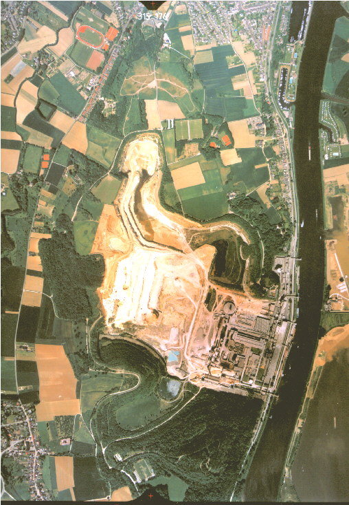
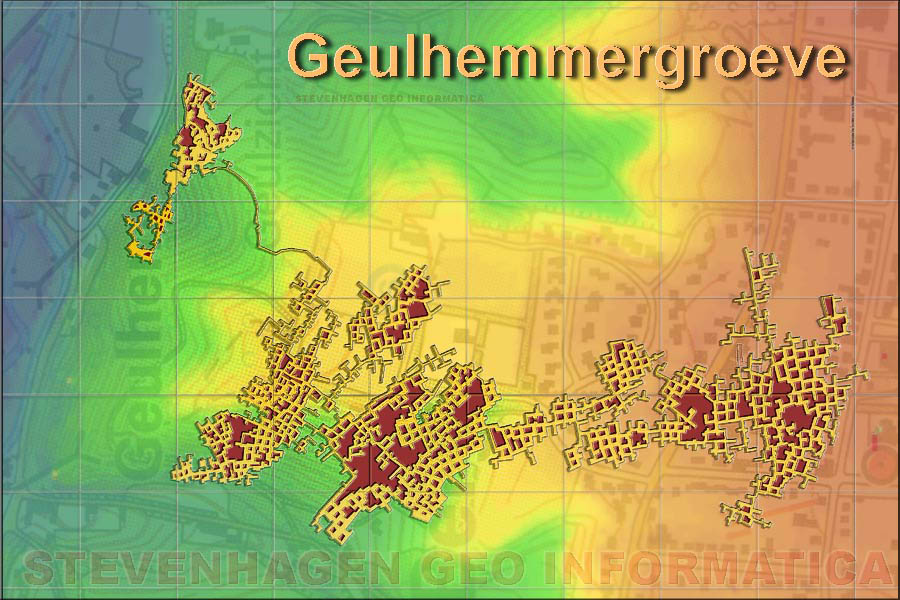
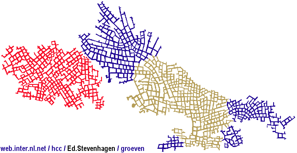
In South Limburg about 180 mine workings are known. Many of these are small but a few represent extensive labyrinths with total gallery lengths of up to 100 km. Fig. 2.6 shows the entrances of the most important mine systems. The majority of the entrances are located at the slopes which rise from the valleys of the river Maas, Geul and Jeker upwards on to the plateaus. Although this thesis concentrates on the mines in the Dutch part of Limburg it might be appropriate to note that most mines in Belgian Limburg are accessible from the plateau by means of a "graet", a winding staircase excavated in the overburden. The largest mine system existed in the St.Pietersberg (Fig. 2.7) south of Maastricht (250 hectares), but has disappeared for at least 80 % due to the open pit mining in the ENCI-quarry, leaving less than 50 hectares of intact mines. The largest mine now is the Sibbergroeve (85 hectares) in the region of Valkenburg. Other large mines are the Gemeentegrot (30 hectares), the Geulhemmergroeve (10 hectares), both also in the Geul Valley, the system of Fallenberg, Boschberg and Cannerberg (in total 31 hectares) excavated in the Cannerberg and the Avergat (20 hectares) near Kanne in Belgium 8). The most extensive mine system in Belgium is the Grote Berg in Zussen (45 hectares). 8 The Dutch word "berg" officially means mountain or hill. However, at the St.Pietersberg and Cannerberg (the hills to the south of Maastricht) also the mine workings themselves are named "berg", according to local dialect. Also in Belgium mines are often denoted "berg" (e.g. Grote Berg). Additionally, the name "gat" (e.g. Avergat) is used. Most mines in Dutch Limburg are known as "groeve". Some room and pillar mines are named "grot", which is incorrect because "grot" means natural cave. |
2.3.1 Mined levels
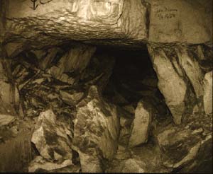
| The Limestone of Maastricht was mined at levels relatively free of flint nodules and promising the best building stone quality (Fig. 2.3). Roof and floor were normally formed by hardgrounds, also named "tauwlagen" (Figs. 8.2, 9.2, 10.2). Mine workings were situated above the watertable. The stratigraphical levels of the calcarenite mines studied here are given by Felder (1979a, 1979b, 1980). The Sibbergroeve has been excavated in the upper part of the Emael Limestone. In the direct vicinity of Valkenburg most mining, including the Gemeentegrot, has been undertaken in the upper part of the Emael Limestone and the lower part of the Nekum Limestone. In the Geul Valley towards the west these layers become situated below the watertable. Here various levels of the Meerssen Limestone were chosen. The mines of the St.Pietersberg and Cannerberg were mainly excavated in the Nekum Limestone. Fig. 2.8 gives an impression of an intact mine system as occurred in the Heidegroeve near Valkenburg before the 1988 collapse. Here mining was undertaken within two levels of the Meerssen Limestone separated by a clearly distinguishable hardground. |
2.3.2 Geological structures affecting
exploitation
| Within a certain mining level the mining direction was determined by the limits of the concession and by the quality and strength of the rock. Furthermore, densely spaced joints, faults, solution pipes and the more rarely occurring vertical flint bodies were avoided. In this section it is shown that, within a certain mining level, the calcarenites can be considered as continuous rocks. |
2.3.2.1 Joints
| The calcarenites are not
jointed at regular intervals. Their spacing is variable and usually tens
of meters, and their persistence rarely exceeds 200 m. Their aperture is
normally less than 1 mm. The majority of joints are subvertical, but inclined
orientations up to 45' also exist. Their strikes show a distribution around
two directions. Generally a major joint set, with a strike ranging from
270' to 320', and a secondary set, striking 0' to 60', can be distinguished
(Fig. 2.9). These joints directions are not related to the topography.
The directions of the major joint set correspond well to the present-day
crustal stress field in Northwest Europe, which is characterized by a NW-SE
oriented maximum horizontal stress (Zoback, 1992; Griinthal & Stromeyer,
1994). This stress field also brings about the still continuing extension
of the NW-SE trending rift system of the Roer Valley Graben (Figs. 2.1
and 2.2). The origin of the minor joint set with an average NE-SW orientation
is less clear. Van den Berg (1994) proposed presently reactivated crustal
buckling generated by NW-oriented compression by the Ardennes. An explanation
could be that the minor joint set developed parallel to the axial plane
of previously existing folds, which became affected by (further) flexure.
This could apply especially to the hinge areas. It is concluded that both
joint sets are most likely of tectonic origin. Near mine entrances, commonly
created in a topographic slope, joints often show an aperture of several
millimeters or even centimeters, and are often filled with clay and affected
by karst phenomena. This applies particularly to joints oriented more or
less parallel to the topographic slope. Since the overburden thickness
is minimal near the entrances, these phenomena rarely have an adverse effect
on pillar stability.
Joints represent planes of weakness and may have an adverse effect on pillar- and roof stability, and on the quality of the building stone. When the joint spacing was small no usable building stone could be mined. It was difficult, if not impossible, to penetrate such a zone of narrow joint spacing, without artificial support, to reach other areas of exploitable limestone. A gallery which penetrated such a zone was called a "strafpijp" (a "penal gallery"), because its creation did not yield material of building stone quality and therefore no income. |
2.3.2.2 Earthpipes
| The upper surface of the Limestone of Maastricht is commonly highly irregular due to solution weathering (karst). Often solution pipes have been formed (Fig. 2.10). They are filled with material from the overlying sediments, usually clay, sand and gravel, and have been observed to penetrate to depths of as much as 40 m. In most mines these earthpipes can be seen, sometimes in isolation but usually in clusters, especially where the calcarenite overburden is thin. This happens mainly near entrances, but sometimes earthpipes can also be seen in clusters in more central parts of a mine system. The diameter of the earthpipes at mining level ranges from a few centimeters to 5 m. Sometimes the soil of the earthpipe has flowed into the mine, resulting in surface subsidence. The rock strength in their immediate vicinity is higher due to a stronger than usual cementation. Accordingly earthpipes often attract miners. |
2.3.2.3 Flints
| Flint nodules are normally concentrated in certain levels of the Maastrichtian Limestone. They are of irregular shape and are orientated parallel to the bedding if developed as discs or lenses. However, locally vertically orientated flint bodies, called "flint curtains", also occur. Felder (1980) described such a flint curtain which was 7.25 m high. |
2.3.2.4 Faults
| Faults are rare in the calcarenite mines. The most prominent fault encountered in a mine system is the east-west trending steeply to the north dipping Klauwpijp-fault (Fig. 2.2). This normal fault shows a vertical displacement of about 20 m and roughly forms the southern boundary of the Gemeentegrot. |
2.3.3 Dimension and shape of pillars
and galleries
| In most mines the height
of the pillars varies between 2 and 3 m.
The
roof and floor were normally formed by hardgrounds, but often the hardground
of the floor was removed to exploit deeper levels. At the St.Pietersberg
deepening generally occurred in two or three stages, resulting in pillars
averaging 6 to 8 m high. Locally deepening
was carried out four to five times and pillars reached a height of 12
to 15 m. In the Avergat a pillar height of 7 to 1 1 m was produced
in usually one stage.
After the blocks had been sawn out large quantities of "waste" rock material remained. After mining, this material, mainly slabs of some em thickness, was stacked up to the roof in niches and against the pillar walls. Due to these "knabbenhopen" the gallery width was significantly reduced. From the beginning of the 20th century the calcarenite mines have been used more and more for mushroom growing. It is estimated that this activity has been performed in at least 90 % of the mines. This development left its mark on the subterranean landscape. In order to create more surface for the mushrooms, the once piled up slabs were spread over the mine floor and pulverized. As a consequence, the mine floor was raised considerably and the three-dimensional form of the mine became more regular. For example, in parts of the Fallenberg the average pillar height is presently 3 m, but was originally 6 m. In the next chapters it will become clear that this must have stabilized the pillars. However, occasionally the "waste" material was transported out of the mine and used for agricultural purposes, for example in parts of the Gemeentegrot. Sometimes further excavation was carried out exclusively for this reason, for example in parts of the Caestert mines in the St.Pietersberg. Here also existing galleries were deepened to produce pulverized calcarenite. Sometimes the floor was only locally broken away and subsequently a new mine system was excavated below the first working level. This happened, for example, in parts of the Gemeentegrot, the Fallenberg and the Geulhemmergroeve. In the Barakkengrot near Valkenburg even three storeys exist. Usually the galleries are 3.5 to 4 m wide and rectangular in vertical cross-section. However, in the Avergat the pillar walls at both sides of a gallery are inclined in such a way that the gallery width increases from 3.5 to 4 m at the roof towards maximally 6 m at the floor. Also, due to "pillar robbing", gallery widths can raise significantly. In parts of the Caestertgroeve, excavated in the southern part of the St.Pietersberg, the cross-section is triangular in shape forming an arch. Mining was carried out here exclusively by using a chisel, resulting in pulverised rock for agricultural purposes. The pillars are generally rectangular and show horizontal dimensions typically varying from 4 to 20 m. The width to height ratio is usually about 1 to 2. When the geological conditions were favourable a highly organized exploitation was possible. Then a regular pattern of pillars resulted as in the St.Pietersberg (Fig. 2.1 1). But more often due to the geology and unskilled mining rather irregular patterns were created. Also due to later pillar robbing irregular pillars with a complex outline resulted (Figs. 2.12 and 2.13). Locally the extraction ratio approached 60 %. |
2.3.4 Overburden composition
| The overburden above the mine roof is usually calcarenite of at least a few meter, overlain by soil units such as Lower Oligocene sands of the Formation of Tongeren, Quaternary clays, sands and gravels of the alluvial Maas sediments and finally loess deposits. The total overburden thickness is at maximum about 50 m. Examples of overburden composition are to be found in Figs. 8.2, 9.2 and 10.2. |
2.3.5 Climate and weathering
| The climate in the mines is fairly constant. The temperature is generally 10 + 2 C' and the air moisture content is 90 to 100 %. Accordingly, weathering inside the mines is generally not serious, except some frost weathering close to the entrance where a zone of some centimeters thickness may be affected. It has been argued that acid vapour resulting from mushroom growing might induce weathering, but this has never been shown indisputably. There might be a slight gradient in moisture content in the outermost centimeter of pillar walls and roof surfaces due to constant evaporation into the mine opening. But slaking, general deterioration and breakdown at the rock surface due to exposure by excavation, has not been observed. |
| 2.4 MINING HISTORY |
Top of page
2.4.1 Flint mines
| Underground mining within the Upper Cretaceous limestones has taken place over a considerable period. Already 3000 years before Christ flint was mined in the upper level of the Gulpen Limestone (Bosch, 1979). Near Ryckholt, to the southeast of Maastricht, many flint mines have been found (Fig. 2.6). The flint layers were reached from a vertical shaft and exploited in irregular galleries radiating from the shaft base. |
2.4.2 Origin of room and pillar mines
| The oldest building stone
mines in the calcarenites were claimed by some to have been made by the
Romans. At one locality near a Roman villa a mine was discovered which
consisted of a shaft giving access to four chambers arranged in the form
of a clover-leaf (Engelen, 1989). The same locally exploited limestone
was probably used for the foundation of the villa. This discovery and other
findings have brought about the idea that the earliest extensive room and
pillar mines near Maastricht and Valkenburg would be of Roman origin. However,
there is no solid evidence at all for this and it is generally believed
that the room and pillar mines were excavated in a later period. Historical
documents and inscriptions in the mines of the St.Pietersberg suggest that
the room and pillar workings came into being in the 13th century (Westrenen,
1988). The first exploitation in the St.Pietersberg was probably carried
out by monks from a nearby monastery. In later times the limestone was
mined by day-labourers.
The limestone was primarily mined to produce building stone but was also used for agricultural purposes. |
2.4.3 Mining techniques
| Right from the beginning
of mining, coarse toothed handsaws were used to cut the rock. Picks, and
later chisels, served to create space for sawing and to loosen the blocks.
The limestone was exploited in blocks, named "stoelen", of about 50 cm
wide, 80 cm deep and 200 cm high. But it must be emphasised that the block
size was not always and everywhere the same. As described above, many existing
mines were deepened one or more times. Amongst others in the Avergat a
gallery height of up to 1 1 m was reached in one stage. The various methods
and the progress and direction of extraction can be reconstructed easily
by studying the scars left on the roof and walls. The blocks were transported
out of the mine by wagon and carthorse. The scars of the wheelnaves indicate
the mining levels. The mining techniques most frequently applied are described
by Van Wijngaarden (1967), Bochman & Hillegers (1984) and Breuls (1985,
1994).
From the second half of the 19th century onwards the Maastrichtian limestone became more and more exploited in open pit mines for the cement industry (e.g. the ENCI-mine in the St.Pietersberg). In other open pit mines, for example near 't Rooth, limestone is extracted mainly for the chemical industry. In the beginning of the 20th century the glass industry was an important consumer of limestone. The exploitation of the building stone mines continued well into this century but has been reduced significantly since 1955. Presently building stone is mined only in the Sibbergroeve and mainly for restoration purposes. Chisel and handsaw have been replaced by electric chainsaw (Fig. 2.14) and the calcarenite is transported by adapted tractors instead of horsedrawn wagons. Reviews of the exploitation history of the Upper Cretaceous limestones are given by Felder (1973), van Westrenen (1988) and Engelen (1989). |
| 2.5 USE OF THE MINES |
| The room and pillar mines have played an important role in the history of Southern Limburg. Once mining was completed they were used for various purposes. |
2.5.1 Non-touristic purposes
| For the inhabitants of the
region the mines have always served as a refuge in time of war as is witnessed
not only by inscriptions on the walls but also by the presence of clandestine
chapels
(Geulhemmer Groeve) and bakeries (St.Pietersberg).
During the Second World War famous Dutch paintings were stored in the St.Pietersberg.
During this period some mines, for example the Heidegroeve, were converted
by the Germans into bomb proof factories for
their war industry (see Section 9.2.3). In the Gemeentegrot and the St.Pietersberg
nuclear
shelters have been built. The Boschberg was used as a NATO
command post from 1954 to 1992.
From about the beginning of the 20th century until the 1960's many mines have been used extensively for mushroom growing. Also, on a smaller scale, chicory and cardoon were grown (Breuls, 1994). At present mushroom growing is only performed in parts of the Avergat and the Noordelijk Gangenstelsel of the St. Pietersberg. Cattle were often housed and in some mines (Geulhemmergroeve, St.Pietersberg) even people have lived. In the Geulhemmergroeve a modern house has been built recently. Some mines serve as storage place. Thus, in the Geulhemmergroeve a collection of various coal types is kept. Because of the stable atmospherical conditions in this mine measuring tapes for the coal mines were calibrated. Also seismographs are housed in the Geulhemmergroeve. |
2.5.2 Touristic purposes
| For centuries the mines have been a curiosity for tourists, who are interested to view not only the workings themselves but also the sculptures and paintings contained within them (Fig. 2.15). The room and pillar mines are of great social-cultural value and their touristic exploitation is economically important for the region of South Limburg. Various inscriptions, some very old, from visitors or from the miners themselves reveal a lot of the history and the social-economical situation throughout the centuries. Hence a large number of mines are kept open to be visited by tourists, mainly mines near Maastricht and Valkenburg. For the latter town the mines form the main tourist attraction and are of essential economic importance. Some of these are modified especially for tourists and contain replicas of prehistoric monsters, are adapted for "survival" activities, or represent a coal mine or Roman catacombs. A few mines are also used for parties and other social activities. |
2.5.3 Access to the mines
| The entrances of the mines
are locked by fences or walls in order to prevent vandalism and to preclude
people entering dangerous areas. Although it is officially prohibited to
enter the mines unaided, frequently people manage to break in. In 1993
two boys got lost due to failing illumination and were found dead three
weeks after their disappearance.
Since various bat species winter inside the mines, the locked off entrances generally comprise openings especially designed to allow their passage. The boys mentioned above proved to have managed to squirm through these bat openings, which had been considered impossible before. Mine workings of some significance have more than one entrance or ventilation shafts. As a consequence the mines are never completely sealed off from the atmosphere outside and always some ventilation exists. |
Internet preparation: E. Stevenhagenwith permission of the author (16 dec 1998)
|
Email : estevenh@xs4all.nl Internet : https://www.sintpietersberg.com https://www.sintpietersberg.com |
De Internetsite "De Limburgse mergelgroeven" is een initiatief van Ed Stevenhagen (Stevenhagen Geo Informatica) om de Limburgse mergelgroeven meer bekendheid te geven en initiatieven tot bescherming van de groeven en onderzoek naar de groeven te stimuleren. |