 |
3.5 ACCOUNT
OF LARGE SCALE COLLAPSES
(pag 36 -54)
3.5.1 The
Fallenberg collapse of 1705
3.6 HAZARDS AND GENERAL CHARACTERISTICS OF LARGE-SCALE COLLAPSES |
Internet preparation: E.
Stevenhagen with permission of the author
https://www.sintpietersberg.com/
|
3.5 ACCOUNT
OF LARGE SCALE COLLAPSES
(pag 36 -54)
3.5.1 The
Fallenberg collapse of 1705
3.6 HAZARDS AND GENERAL CHARACTERISTICS OF LARGE-SCALE COLLAPSES |
Pillar stability and large
scale collapse of abandoned room and pillar limestone mines un south-Limburg,
The Netherlands
R.F. Bekendam, ISBN 90-9011726-1
Internet preparation: E.
Stevenhagen.
| 3.5 ACCOUNTS OF LARGE-SCALE COLLAPSES |
| A brief description of significant large scale collapses in the past is presented here to reveal the characteristics of these events and their consequences |
3.5.1 The Fallenberg collapse of 1705
| The Fallenberg is one of the calcarenite mines excavated in the Kannerberg-hill, to the south of Maastricht. At present five major mine workings can be recognized: the Fallenberg, the Boschberg, the Kannerberg, the Muizenberg and the De Keel mine (Fig. 3.8). On a map produced at the end of the 19th century the outlines of a collapse area of about 3 hectares in the southeastern part of the present Fallenberg is indicated. This area is accompanied by the date of 1705. Legend has it that baroness De Dopff, wife of the governor of Maastricht, and her two children were killed by the collapse, seated in their coach, when they took shelter in the mine from a rain storm (Schreiner, 1960). The age of the collapsed part is difficult to assess. According to Schreiner the exploitation must have started in the 17th century or earlier. Probably long-term deterioration by creep played a part in the collapse. The mine was originally known as the Jufferenberg or St.Lambrichtsberg (De Bruin, 1903) but was named the Fallenberg after this collapse. This collapse is studied in more detail in Chapter 10. |
3.5.2 The St.Pietersberg collapses of 1794 and 1809
| The collapse
of 1794 in the northern mine workings, known as the Noordelijk
Gangenstelsel, was generated in an unusual way. During a siege of
the city of Maastricht by the French army it was decided to destroy the
mine workings beneath the fortification of St.Pieter held by the Dutch
and the Austrians. By means of a considerable amount of gunpowder a pillar
was blasted triggering an underground collapse of about 3
hectares (Fig. 3.9). Where the pillar had been blown up a cavern
was generated. This arch shaped cavern, known as the "Koepelgrot", is about
8 m high and shows a span of about 15 m. The explosion had occurred well
to the south of the fortification and the fortification was not damaged.
A historical study of Van Schaik (1942) revealed that a later collapse
occurred in 1809, possibly due to the damage
induced in 1794. The southern part of the Noordelijk Gangenstelsel and
the northern part of the mine workings of the Zonneberg
were destroyed. In total 9 hectares were affected.
According to a French report of 1843 surface subsidence could still be
recognized then. In 1813 the French troops
placed explosives again, this time in the roof (Venmans, 1985). Further
movements were induced by the blasts in the area already damaged and in
1817 more galleries in the most northern part
of the workings collapsed.
In 1929 and 1930 the collapsed area of 1809 within the northern mine workings was thoroughly investigated by Van Schaik for the benefit of the construction of a tunnel. An account of this, adventurous study is presented in Van Schaik et al. (1983). The area, accurately mapped by the French between 1794 and 1796 before it collapsed, proved to be difficult to penetrate. It was just possible to clamber or crawl over the debris piles. At many locations the roof proved to have collapsed up to several meters above the original roof level. Sometimes an intact gallery was discovered surrounded by debris. In order to cross the collapsed area completely from west to east it was necessary to remove the debris at a few locations. Pillars had normally failed resulting in an hourglass shape and often the roof had collapsed forming an arch. According to Van Schaik pillars had been modified in shape but he wrongly assumed that they had maintained their original load carrying capacity. |
3.5.3 The Gemeentegrot collapse of 1845
| Fig. 3. 10 shows the present
extent of the Gemeentegrot near Valkenburg.
A collapse in 1845 of about 1.5
hectares in the eastern part of the present Gemeentegrot was reported
by the mine inspector Buttgenbach (Archives of the State Supervision of
Mines; Knubben, 1995). Some days before the collapse miners had observed
inauspicious signs and most of them had left the mine. On the 18th of December
the remaining miners were alarmed by a violent cracking sound and fled
immediately. A few moments later the collapse occurred. Nobody was injured
or killed. A local journal of the 1st of January 1846 reported that at
the surface an area of 800 M2 had subsided and that cracks outside this
area heralded additional ground movements. Additional subsidence occurred
indeed on the 8th of January.
By some it was stated that the collapse had been the result of recent overmining, because at some locations older parts of the mine had been undermined by lower galleries. However, Buttgenbach stressed that due to mining activities in the past also older parts of the mine might have been already deteriorated before the collapse. Not only the recently excavated mine working had collapsed but also the older part of the mine, which had remained intact for more than a century. Hence it is quite possible that the collapse was brought about by both long-term deterioration of old mine pillars and recent overmining. Note that at that time no supervision existed in that mine and most other mines, and that, as a consequence, mine workers were not kept from widening galleries and narrowing pillars too much. |
3.5.4 The Gemeentegrot collapse of 1886
| Another large-scale collapse of about 1.8 hectares occurred in the southern part of the Gemeentegrot (Fig. 3.10). This collapse was described in the annual report of the State Supervision of Mines of 1886. It was stated that in the collapsed area excavation had ceased at least 30 years ago and that pillars were considered too small. Thus it appears that the collapse resulted from time dependent deformation of highly stressed pillars. Nobody was injured or killed. Damage at the surface was limited to a few small cracks of 2 to 5 cm width which soon disappeared. |
3.5.5 The Fallenberg' collapse of 1920
| This is one
of the largest collapses in the history of the calcarenite mines.
About 7 hectares collapsed suddenly (Fig.
3.8). The annual report of the State Supervision of Mines (1920)
reported extensive fractures with vertical displacements of about 10 cm.
at the surface above the mine. Several dolines had been formed due to flow
of soil into underlying karst structures. People in the vicinity of the
mine felt an earthquake and a pronounced thunder-like sound. The collapse
must have been accompanied by a strong air blast because the calcarenite
dust near the new entrance (Fig. 3.8) was completely flattened out and
the numerous foot prints had vanished. The collapse area was blocked at
its perimeter by rock debris. All pillars in the direct vicinity of the
collapsed area had become heavily fractured. Large slabs had been formed
along their walls.
The large-scale collapse was not unexpected. Near the northern entrance (Fig. 3.8) pillars were overstressed due to pillar robbing at the end of the mining period. Many galleries were too closely spaced. Schreiner reports that the Jesuits had observed deterioration of roof and pillars at several locations. A small-scale collapse had been mentioned by a local newspaper of 1903, which attributed the damage to a tram passing the Jeker Valley during that period. In 1911 the State Supervision of Mines had warned of roof instability at several locations (State Supervision of Mines, 1920). A considerable time span exists between the end of the mining activities in about 1880 (Schreiner, 1960) and the collapse. Hence long-term deterioration must have been an important factor, together with overmining. Schreiner states that the three days preceding the collapse were accompanied by heavy rain fall. The resulting increased water content of the overburden layers and the increase of vertical pillar stress as a consequence might have triggered the collapse. This collapse is extensively studied in Chapter 10. |
3.5.6 The Muizenberg collapse of 1926
| The account of this collapse
of about 5.5 hectares is based on the Annual
Report of the State Supervision of Mines of 1926.
Additional facts can be found in Breuls (1984). The mine comprised two
storeys. An upper level, 3 to 4 m thick and of modest extent (Fig. 3.11),
had been mined more than a century ago and was used for mushroom growing.
No map exists of this excavation, only its outline has been approximated.
The main part of the mine was excavated in a lower level of 6 to 8 m thickness,
separated from the higher level by a "tauwlaag" of 1 to 1.5 m thickness.
Only part of the lower mine working is indicated on maps (Fig. 3.1 1).
Mine workers were still extracting calcarenite in this storey. The exploitation
front at that time was located well to the north of the area about to collapse.
Before the large-scale collapse fragments of pillar sides had fallen off
and locally the layer separating the upper and lower storeys had collapsed.
The day before the collapse there was a rumour in the nearby village of Kanne that unusual ground movements were occurring in the mine. The large-scale collapse occurred early in the morning of the 11th of May, when six workers were transporting the last calcarenite blocks out of the mine as fast as they could. At that time seven mushroom growers were standing in a brick shelter just beside the entrance. They heard a thunder-like sound coming out of the interior of the mine. Within one minute this noise suddenly increased tremendously in intensity and was accompanied by an earthquake. Then a strong air blast projected the seven men against the talus of the nearby road. Two of them were killed. Four of the six men inside the mine tried to escape but were stroke by the air blast which killed one of them. Both men who stayed inside the mine were buried together with their carthorse. About one hectare in front of the entrance had been covered by dust. Bricks and beams from the constructions built near the entrance and even rock fragments from inside the mine had been projected forward and deposited in front of the entrance. At the surface normal faults and subsidence troughs developed contouring the underground collapse from the southwest to the northeast. Several sinkholes formed due to flow of soil into underlying karst structures (see Fig. 3.1 1). However, it is not completely certain that these sinkholes did not already existed before the collapse. From the Cannerberg debris piles were observed at points A to F, which reached above the original roof level and blocked the entrance towards the collapsed area. A tunnel was made starting at point C in an attempt to rescue both men inside the collapsed area, but after a month this work had to be given up. Neither of them was found. Considering that the collapse occurred in the older parts of the mine it can be hypothesized that long-term deterioration of the calcarenite has played a role. According to the report cited above the relatively low uniaxial compressive strength of 1.4 MPa for the calcarenite in the Muizenberg must have been an important factor as well. |
3.5.7 The Roosburg collapse of 1958
| The Roosburg is situated
near the village of Zichen in Belgium, about 8 km to the southwest of Maastricht
(Fig. 2.7). The abandoned mine was extensively used for mushroom growing
which provided work for about 400 people. The account given below is based
on newspaper-articles found in the Archives of the State Supervision of
Mines in Heerlen (Fig. 3.12). On the 23th of December 4
hectares of the mine collapsed killing 18 workers and severely injuring
3. The large-scale collapse was preceded by significant roof collapses
and fracturing and spalling of pillars. During the days before the collapse
cracking sounds had been heard extensively by the workers in the mine.
Against their own better judgement they continued harvesting the precious
mushrooms. Just before the collapse 20 workers moved to another part of
the mine at some distance of the area about to collapse, where cracking
sounds were less abundant. This saved their lives. Suddenly the sound of
thunder was heard, pillar walls collapsed and dust and stones were projected
through the galleries. They run towards the collapsed area and found a
fatally injured woman hurtled from her bicycle against a pillar wall by
the air blast. Seventeen workers were buried by the collapse. Six of them
were found during rescue operations. The following days more collapses
occurred affecting at least 2 hectares additionally and impeding the rescue
parties. It appears from the accounts of the rescue parties that they could
only penetrate through the collapsed area by creating a new open tunnel
with extra support (Figs. 3.13 and 3.14). Only locally open space was encountered
within the collapse. Some pillars, even in the centre of the collapsed
area, were in reasonable state. Pillars were shortened considerably during
the collapse and fragments from the pillar walls which had been pushed
sidewards had filled the galleries. Additional roof falls might have resulted
in further blocking of the galleries.
The strong air blast which had killed one person projected the steel gate at the entrance 50 m away. The area in front of the entrance was covered with dust. Surface subsidence occurred over the whole collapsed area. The subsided area was bounded by normal faults. Mining had ceased long before the collapse. Hence long-term deterioration of the rock must have been important. |
3.5.8 The Heidegroeve collapse of 1988
| In the Heidegroeve, situated near Valkenburg (Fig. 2.7), the most recent large-scale collapse occurred. At this occasion the results of a collapse could be studied, which were not obliterated during the passage of time. Surveys were undertaken after the event, both underground and at the surface. The following description of the immediate effects of the mine collapse is based on the work of Price (1990). A more extensive study of the collapse is presented in Chapter 9. |
3.5.8.1 Subsidence features
at the surface
| On 23 June 1988 the seismograph
in the Geulhemmergroeve (about 2.8 km from the mine) recorded an earthquake
shock at 18h 13m 34 sec Dutch summertime. The shock lasted less than 45
seconds as indicated by the seismogram (Fig. 3.15). "Strong" motion ceased
after about 10 seconds. The shock was also recorded by the seismograph
at Epen, about 12.7 km distant, and perhaps at Kerkrade, about 17 km away.
Shortly afterwards walkers in the Polferbos observed cracks in the footpaths
and raised the alarm. An examination of the mine showed that the southeastern
part, about 30 % (0.4 hectares) of the mine,
appeared to have collapsed. Fig. 3.16 shows the limits of the collapse
as seen underground and the ground shears bounding the surface subsidence.
The collapse underground presumably extends to the southeastern limits
of the mine. The presence of two shafts facilitated matching of underground
and surface maps. Obviously the collapsed zone underground corresponds
more or less with the subsidence area at the surface. As a consequence
of the collapse rock dust and pieces of rock appeared to have been blown
out of the mine to the other side of the Plenkertstraat. The plate steel
door at the mine entrance was observed to be bent outwards but later inquiries
indicated that this damage could wholly or partially be attributed to vandalism.
At the surface above the collapsed part of the mine normal faults partially bounded an elliptical area about 100 m long and 70 m wide (Figs. 3.17 and 3.18). The outer normal faults showed downward displacements of up to 0.8 m towards the centre of the subsidence area (Fig. 3.17). Their heave was up to about 0.25 m. Inner normal faults parallel to the outer faults showed lesser vertical and horizontal displacements. Their downward displacements were generally towards the outer normal faults, resulting in a graben-like structure in between the inner and outer faults. The inner normal faults were probably antithetic relative to the outer main faults. A fence running alongside the main footpath was damaged in compression. Shearing of one part of the fence indicated horizontal shortening of about 10 cm in that part of the fence (Figs. 3.17 and 3.19). The faults were fortunately confined to the wooded area, stopping about 30 m short of the restaurant to the south and not reaching the artificial "bob-sleigh run" to the east (Fig. 3.17). The soil exposed in the fault planes is composed of mainly silt (loess deposits) or a mixture of dominantly sand and clay (Tongeren Sands). The overburden in the subsidence/collapse area consists of 21-25 m of calcarenite covered by 15-30 m of soil. About 15 m to the NNE of the easternmost shaft a circular depression about 1.5 m deep can be seen. It is not known if this was formed as a result of the collapse or already existed. However, it should be noted that other large-scale collapses, i.e. the collapse of the Muizenberg, were accompanied by the formation of sinkholes at its perimeter (Fig. 3.1 1). It probably represents a doline, resulted from the flow of soil into a solution pipe of the underlying calcarenite. The solution pipe did not reach the mined level as observed before the collapse by visitors of the mine. |
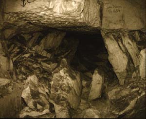
3.5.8.2 Collapse features
underground
| A pillar survey was undertaken in September 1988 (Fig. 3.16). All galleries at the periphery of the collapsed area were blocked as result of roof falls (Fig. 3.20). In between the collapsed area in the southeast and the intact northwestern part of the mine a transition zone of about 50 m broad existed, in which pillar damage decreased gradually towards the entrance. Especially in the 4.6 m high workings severe pillar deterioration was encountered (Fig. 3.21). Several pillars could be classified as failed. Often brick cladding had parted from the pillar walls and fallen on the floor. |
3.5.8.3 Evidence of long-term
deterioration
| Also here the factor time
is important in the process of pillar deterioration preceding the collapse.
The last mining activities occurred in the 1930's. During World War II
the Germans used the mine and made additional excavations, possibly reducing
the stability in the long term. The Heidegroeve appeared to be safe until
the 1980's when a deterioration of the mine was observed, increasing significantly
during the summer of 1987. The State Supervision of Mines inspected the
mine weekly and observed additional pillar damage every visit (personal
communication, W. Misere). For example one week a new crack was noticed,
a week later some mm. of movement had occurred along this crack, after
two weeks the crack was extended and the whole side of the pillar had moved
several millimeters into the gallery along that crack, and after three
weeks the whole pillar side had fallen off on the floor.
Also fresh calcarenite dust was observed at several locations every week. The major part of the mine was declared unsafe and the mushroom grower who was working in the mine at that time stopped the exploitation. The Heidegroeve mine was closed and abandoned. In June 1988, within one year, the southern part of the mine collapsed. This case shows that a mine, being stable for many years, can deteriorate and collapse within ten years. It is known that there was heavy rainfall during the weeks preceding the collapse. The resulting increase in overburden weight might have triggered the collapse. |
| 3.6 HAZARDS AND GENERAL CHARACTERISTICS OF LARGE-SCALE COLLAPSES |
It can be concluded that
a large-scale collapse is accompanied by the following hazards:
a collapse is almost immediately followed by subsidence at the surface. The perimeter of the subsided area often corresponds with the outline of the underground collapse and is generally at least partly characterized by normal faults and sinkholes. The normal faults may show horizontal and vertical offsets of several decimeters. Obviously such phenomena constitute a hazard to people and buildings. |
Other characteristics,
revealed by the accounts presented above, are:
intact pillars adjacent to the collapse area are sometimes loaded more severely, finally resulting in an additional collapse. |
Internet preparation:
E. Stevenhagen with permission of the author
https://www.sintpietersberg.com/